HONDEX
HONDEX 5-inch Wide LCD Portable Plotter Fish Finder PS-611CNⅡ HONDEX 43727
Product Number: 43727Couldn't load pickup availability
Product details
HONDEX by HONDA ELECTRONICS
5-inch wide LCD portable plotter fishfinder PS-611CNⅡ
No.43727 Standard Built-in TD04A
● Output: 100W Frequency: 200kHz (Deep specification 50/200kHz)
● Dimensions: W173 x D191 x H173mm Weight: Approx. 0.7kg
● Continuous operating time: Approx. 8 hours when using 8 AA batteries
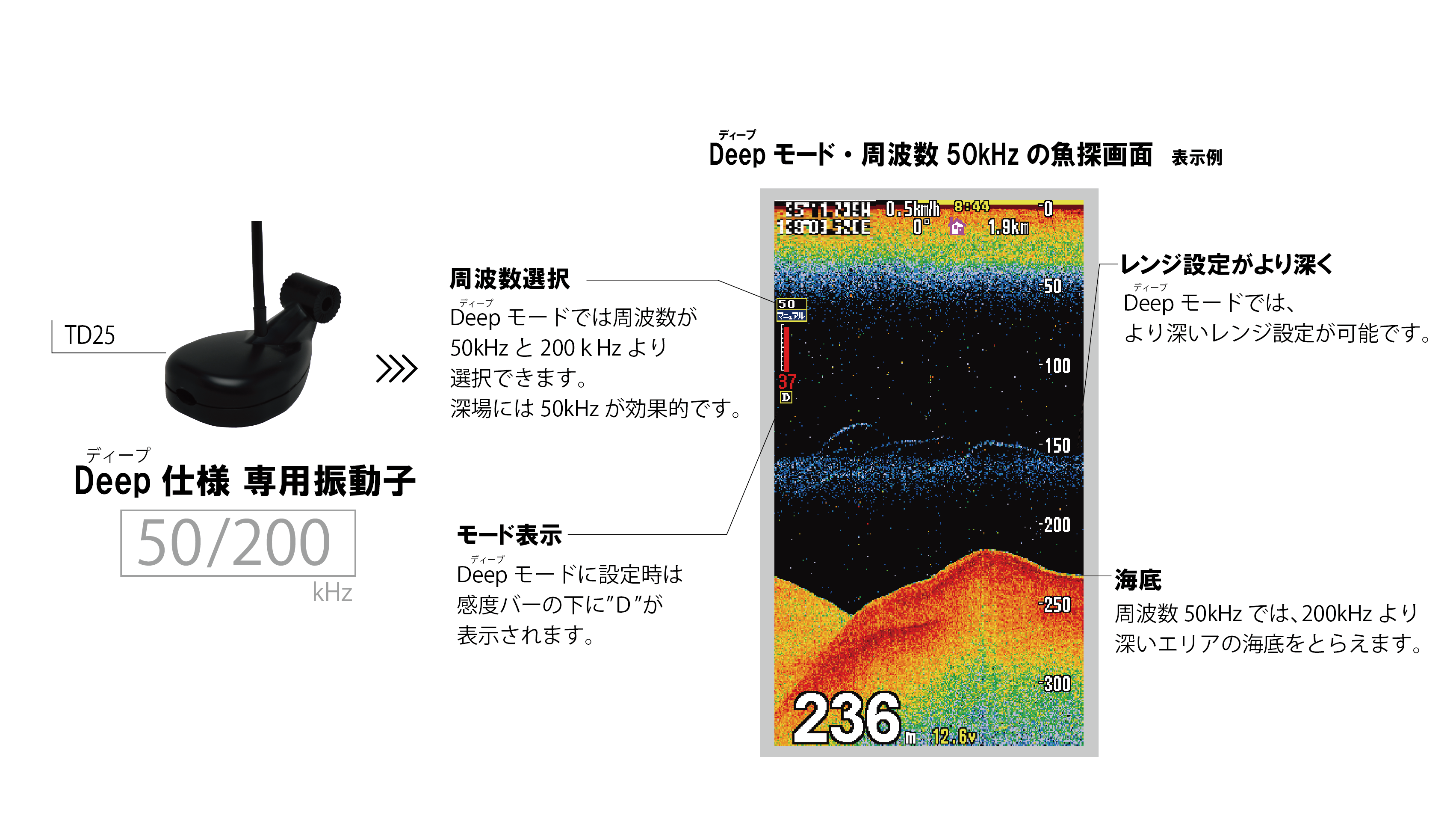
● The Deep specification model can select between 50kHz and 200kHz, allowing it to display at deeper water depths. *Only when using TD25
Start using a fishfinder easily and enjoyably! HONDEX PS Series.
The PS series offers compact size, reasonable price, and user-friendly operation, making it a series that even first-time fishfinder users can confidently use.
Portable style with integrated battery box
It can be used with 8 AA batteries, so you can install it anywhere. In addition, the base and front protective cover can be folded, making it easy to carry. Perfect for small boats!
*Approx. 8 hours of continuous use (varies depending on usage environment).
New feature! Equipped with Deep mode
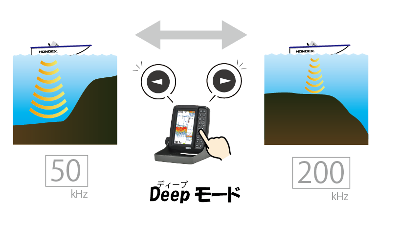
The unit's mode can be switched depending on the water depth to be used. When the fishfinder mode is set to "Deep" and the TD25 transducer is connected, you can select between 50kHz and 200kHz fishfinder frequencies. 50kHz has the characteristic of reaching even deeper water depths than 200kHz, which is very useful for fishing in areas where 200kHz does not reach.
*TD25 is required to use Deep mode.

Easy frequency switching with one-touch keys

In Deep mode, the fishfinder frequency can be switched between 50kHz and 200kHz. Pressing the left/right keys allows for quick one-touch switching between 50kHz/200kHz.
*Only when Deep mode is set / TD25 is connected / fishfinder screen is displayed
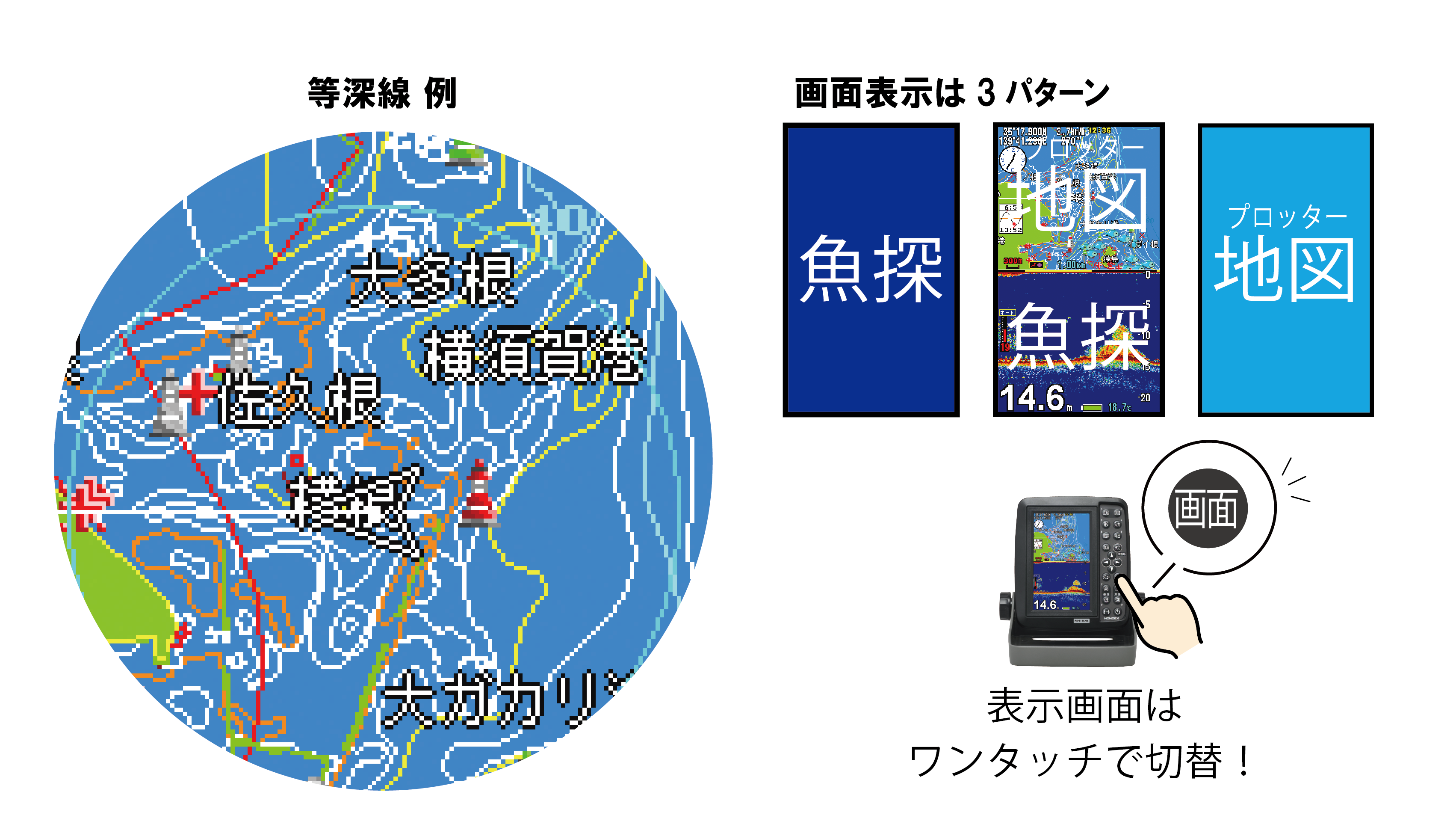
Ultra-compact with built-in GPS antenna & preloaded national map!
Compact design with a 5-inch wide LCD in the conventional model's casing.
With a built-in GPS antenna, no antenna wiring is required. It comes with a preloaded national map, allowing simultaneous display of the plotter and fishfinder screens. You can mark points of interest while observing the fishfinder's reactions. With abundant information and color display, it navigates to your destination clearly. The map/fishfinder screens can be easily switched with a single touch.

Excellent visibility with a clear screen! Features bonded LCD!

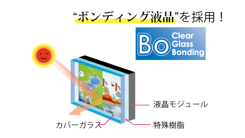
Bonded LCD is used for clear visibility even in direct sunlight!
Visibility has been improved by bonding the LCD display and cover glass with special technology.
Compatible with polarized sunglasses!
There is no color shift even when wearing polarized sunglasses, achieving a clear screen display from any angle.
Full-featured fishfinder & plotter functions!
Fishfinder Auto Function
The fishfinder auto function is included so that even beginners can use it immediately. By using auto range (depth) and auto gain (sensitivity), it operates fully automatically, so no special operation is required. The ON/OFF status of the auto function is displayed on the left side of the fishfinder screen.
Auto range automatically switches the fishfinder's depth (display range) so that the seabed is always displayed. Auto gain automatically adjusts the sensitivity so that the seabed response is always constant. (Auto range and auto gain are designed to be turned ON/OFF simultaneously.)
Fish Mark Display
Fish echoes are displayed with fish marks.
This is an ideal feature for those using a fish finder for the first time or who are not yet familiar with fish finder displays, as it allows you to intuitively confirm echoes.
It also has a fish alarm function that identifies fish echoes and alerts you with an alarm.
You'll know when there's a fish echo even when you're not looking at the fish finder.
Magnified Display
The area near the seabed can be magnified by 2x, 4x, or 8x, clarifying bottom-dwelling fish schools, undulations, and the density of fish schools.
Mark and track points! Set destinations!
You can mark and save fishing spots or points of interest. You can also save your tracks, so you know where you've been, which is convenient for future trips. When you set a destination, a straight line connects your current position to the destination, showing you the approximate distance and time to reach it.
Front Wide
Front Wide allows you to display a wider map in the direction of travel.
Display of date, time, and depth at marked locations
Hovering over a registered mark displays the registered date, time, and depth data (if an optional water temperature sensor is installed, water temperature can also be displayed).
Seabed discrimination function shows changes in seabed composition at a glance!
The hardness of the seabed is displayed as a number (0-20) and a graph. A higher number indicates a higher probability of a hard seabed. The graph display also allows you to grasp approximate changes in seabed composition.
<Precautions regarding the PS-611CNⅡ's GPS antenna>
*Please use the unit in as vertical a position as possible. It may not receive signals if tilted more than 30 degrees.
*Reception may not be possible depending on the installation location of the unit. Please install it after checking the following:
(1) Sufficiently far from other electronic equipment (radios, fish finders, radar)
(2) Sufficiently far from equipment using motors such as rotating windows and wipers
(3) Sufficiently far from the engine
(4) In a location free of obstacles (metals, damp wood, etc.) overhead
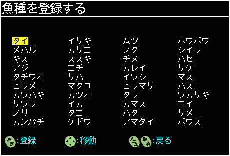
You can register and search for fish names (species)!

The "Fish Data Function" allows you to register fish names (species) when registering a point.
You can also search for registered fish data.
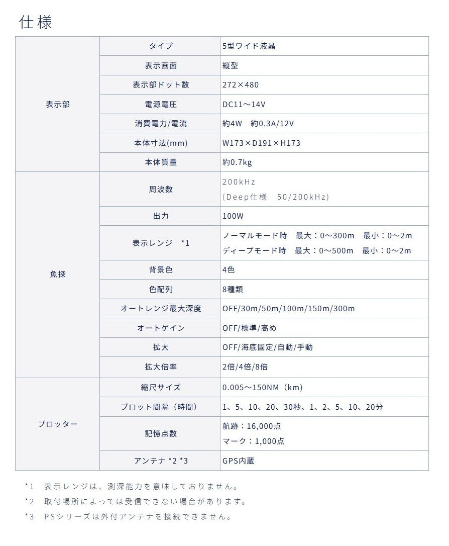
Specifications
| Display | Type | 5-inch wide LCD |
| Display Screen | Vertical | |
| Display Pixels | 272×480 | |
| Power Voltage | DC11~14V | |
| Power Consumption/Current | Approx. 4W Approx. 0.3A/12V | |
| Unit Dimensions (mm) | W173×D191×H173 | |
| Unit Weight | Approx. 0.7kg | |
| Fish Finder | Frequency |
200kHz |
| Output | 100W | |
| Display Range *1 | Normal mode: Max: 0~300m Min: 0~2m Deep mode: Max: 0~500m Min: 0~2m |
|
| Background Color | 4 colors | |
| Color Scheme | 8 types | |
| Auto Range Max Depth | OFF/30m/50m/100m/150m/300m | |
| Auto Gain | OFF/Standard/High | |
| Magnification | OFF/Bottom fixed/Auto/Manual | |
| Magnification Ratio | 2x/4x/8x | |
| Plotter | Scale Size | 0.005~150NM(km) |
| Plot Interval (Time) | 1, 5, 10, 20, 30 seconds, 1, 2, 5, 10, 20 minutes | |
| Memory Points | Tracks: 16,000 points Marks: 1,000 points |
|
| Antenna *2 *3 | Built-in GPS |
*1 The display range does not indicate the depth measurement capability.
*2 Reception may not be possible depending on the installation location.
*3 PS series units cannot connect to an external antenna.
Compatible Options (Sold Separately)
| Transducer | TD28 (8m-3P), TD04C (6m-3P), TD08 (2m-3P) |
| Power Cable | DC06 (2m) |
| Water Temperature Sensor | TC01C (6m), TC01G (3m) TC03-05 (5m), TC03-10 (10m) |
| Mounting Bracket Set | TKS01 |
| Universal Pipe | BP05, BP10 *SK05 tip fitting is required when using TD28. *SK06 tip fitting is required when using TD08. |
| USB Power Cable | UD01, UD02 |
| Sun Visor Hood | SF10 |